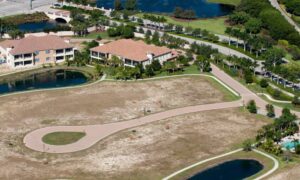
Redevelopment in Caldwell is picking up speed. Old car washes, corner lots, and even former gas stations along Cleveland Boulevard, Ustick, and 10th Avenue are turning into new opportunities. But before a shovel hits the ground, one thing must happen: ordering an ALTA title survey. This survey is the gold standard for lenders, title companies, and city planners. It not only shows where property lines sit but also uncovers the easements, utilities, and restrictions that could affect your project. If you want your redevelopment to move forward without delays, you need to get this step right.
Why a Redevelopment Needs More Than a Simple Survey
Most people think a property survey just finds the corners of a lot. While that works for basic home sales, redevelopment projects in Caldwell are a different story. These sites often carry decades of history—old easements, abandoned utilities, or floodplain issues that no one notices until plans are in motion.
A simple boundary survey won’t uncover those risks. An ALTA title survey will. It’s designed to tie the title commitment, county records, and the actual fieldwork into one map. For a redevelopment, this matters because:
- Lenders and title companies won’t close without it.
- City reviewers need the survey to check zoning compliance.
- Engineers rely on it as the base for site design.
Skipping or rushing this step can mean permit delays, costly redesigns, or even a stalled project.
Step One: Start With Zoning and Property Reports
Every redevelopment begins with zoning. In Caldwell, that means requesting a zoning property report from the city. This document explains setbacks, permitted uses, and parking rules. It connects directly to Table A Item 6, which requires surveyors to document zoning classification and setback dimensions on the survey map.
Why does this matter? Imagine buying an old car wash and planning to turn it into a coffee shop with a drive-through. If the city’s setback rules push the building line farther back than you expected, the entire site plan changes. By pulling the zoning report first, you’ll avoid surprises and give your surveyor the information they need to show the limits on your ALTA title survey.
Step Two: Dig Into Easements and Rights-of-Way
Caldwell’s older parcels often carry hidden easements. Some date back to the 1960s when utility corridors were less organized. Others may involve shared access drives that no one mentioned during negotiations.
To find them, surveyors use Canyon County GIS and recorded plats. These records help confirm if your site has a utility right-of-way running through it or if a road easement cuts across the property. On your ALTA survey, this connects to Table A Item 19, which documents offsite easements that benefit or restrict the land.
Missing an easement early can derail redevelopment. For example, if you plan a new parking lot only to find a sewer line easement under half the site, you’ll face redesign costs and delays. Checking these records upfront keeps your project on track.
Step Three: Choose the Right Table A Items for Redevelopment
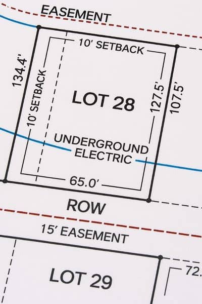
One of the most important parts of ordering an ALTA title survey is knowing which Table A items to include. These are optional details that go beyond the standard requirements, and they can make or break a redevelopment project.
For Caldwell sites, the most valuable Table A items are:
- Item 3 – Flood Zone Classification: Caldwell parcels near Indian Creek or the Boise River may fall within FEMA flood zones. This information is critical for lenders.
- Items 7a, 7b, 7c, 8, 9 – Building Dimensions, Height, Parking Counts: Redevelopment often involves reusing or removing existing structures. Documenting these helps engineers design around what’s already there.
- Item 11 – Underground Utilities: Old gas stations or car washes usually have complex utility histories. This item ensures utilities are located, mapped, and confirmed.
- Item 16 – Evidence of Earthwork or Site Work: If grading or excavation has already started, lenders and city reviewers want it documented.
- Optional Item 19 – Offsite Easements: Useful when shared access or drainage runs through neighboring parcels.
By working with your surveyor to select these items, you’ll create a survey that lenders, engineers, and the city can all rely on.
Step Four: Match the Survey With Design Review
Redevelopments in Caldwell’s City Center and Indian Creek Corridor come with design review steps. If your ALTA survey doesn’t match your site plan submittals, reviewers may send it back. That means wasted time and rework.
Your surveyor should know how to prepare deliverables that align with these requirements. For example, if your project is within the corridor, the ALTA should highlight pedestrian access, building placement, and setbacks clearly so city staff can compare it with your design package.
This is where local knowledge counts. A surveyor who understands the review process can save you weeks of back-and-forth.
Step Five: Ask for the Deliverables That Matter
Not all survey maps are created equal. For redevelopment projects, it pays to be specific about what you want delivered. The most helpful formats include:
- A 1”=20’ scale base map that your civil engineer can use directly.
- Utility sheets that make it easy for contractors and city reviewers to follow.
- A lender-ready certification line that matches the title commitment exactly.
- Digital files (CAD, shapefiles) for seamless integration into design and GIS systems.
When you order the ALTA title survey, ask your surveyor to provide these upfront. It will save your team hours of adjustments later.
Why Timing Is Everything
One of the biggest mistakes developers make is waiting until the last minute to order their survey. An ALTA title survey can take weeks to complete, especially if it involves utility locates, flood mapping, and zoning research. If you delay, your lender might hold closing, or the city might postpone approvals.
By ordering early, you’ll have the survey in hand when you need it. More importantly, you’ll uncover problems before they turn into roadblocks.
Conclusion:
Redevelopment offers plenty of opportunities, but it also carries risks. Old easements, floodplain issues, and utility conflicts can derail even the best project. The good news is that an ALTA title survey gives you the full picture before money and time are wasted.
By starting with zoning reports, checking county records, selecting the right Table A items, and matching city review needs, you’ll create a survey that clears the way for financing and approvals. Order it early, ask for the right deliverables, and work with a licensed surveyor who knows the area.
Redevelopment is complicated enough. Your survey shouldn’t be.
