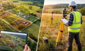
How To Find Your Property On FEMA’s Flood Insurance Rate Maps

What are FEMA flood maps?
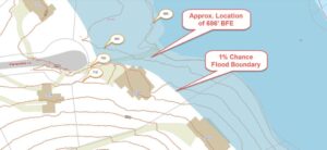
FEMA’s Flood Insurance Rate Maps (FIRMs) or just Flood Maps are provided after a flood risk assessment has been completed or updated for a community.  This study is known as a Flood Insurance Study.  The FIRM gives you the Base Flood Elevations (BFEs) and insurance risk zones in addition to floodplain boundaries.  The FIRM may also show a delineation of the regulatory floodway.

Once the “insurance risk zone”  (commonly referred to as the flood zone) is determined, actuarial rates, based on these risk zones, are then applied for newly constructed, substantially approved, and substantially damaged buildings.  FEMA uses these rates to determine the insurance rate you will pay for flood insurance

FEMA’s Digital Flood Maps

FEMA discontinued the production and distribution of paper flood maps in 2009 as part of its Digital Vision Initiative. This affected all the Flood Maps, boundary information, and study reports. However, clients can still view the products for free through their website or buy them in digital format.

To view these flood maps online, go to FEMA’s Map Service Center and key in your address (hi-lited area shown here) search for your home.  This will prompt you to then select the map that covers your area.  The Flood Maps are somewhat cumbersome to use online. It is best to go through the tutorial on the bottom right of the address search page for an easier and more effective use of the GIS map.
author avatar
Surveyor

More Posts

Surveying instrument focused on a paused road construction site with an excavator in the background representing how road delays impact an alta title survey
alta survey
Surveyor

ALTA Title Survey Risks When Road Projects Pause

When Boise’s much-anticipated State Street rebuild suddenly hit pause, most people saw it as a traffic story. But if you’re planning a purchase, loan, or development project in the Treasure Valley, it’s more than that. It’s also a land surveying story—and it may directly affect your ALTA Title Survey. The

Read More »
A surveyor’s tripod stands under a glowing night sky, symbolizing how solar storms and the Northern Lights can affect ALTA Land Title Survey accuracy.
alta survey
Surveyor

How Northern Lights Affect Your ALTA Land Title Survey

Last week, Idaho’s skies erupted in color. The Northern Lights shimmered above Eagle and Boise, painting streaks of pink and green across the night. Phones came out fast; social feeds filled even faster. It was one of those rare “did-you-see-it?” moments that had everyone talking. But while the show amazed

Read More »
Land surveyor using tripod equipment at a redevelopment site during an ALTA title survey.
alta survey
Surveyor

ALTA Title Survey: The Exact Table A Checklist You’ll Need

Redevelopment in Caldwell is picking up speed. Old car washes, corner lots, and even former gas stations along Cleveland Boulevard, Ustick, and 10th Avenue are turning into new opportunities. But before a shovel hits the ground, one thing must happen: ordering an ALTA title survey. This survey is the gold

Read More »
Aerial farmland with irrigation canals highlighting why an ALTA survey is needed to identify hidden easements
alta survey
Surveyor

ALTA Survey: Protecting Buyers from Hidden Easements

If you’re buying land, you’ve probably heard the term ALTA survey. It might sound like just another step in the closing process, but here’s the truth: in Boise, Meridian, Nampa, and Kuna, an ALTA survey can be the difference between a smooth purchase and a deal full of expensive surprises.

Read More »
Two neighbors arguing over a backyard fence showing the need for an alta title survey
alta survey
Surveyor

ALTA Title Survey: Protecting Homeowners from Fence Disputes

If you’ve ever scrolled through Reddit, you’ve probably seen a flood of frustrated homeowners venting about fences and neighbors. In Idaho, it’s no different. Posts about ripped-out stakes, surprise fences, and “my land vs. your land” arguments keep popping up. What many people don’t realize is that these conflicts often

Read More »
Snake River in Idaho with surrounding cliffs and farmlands highlighting environmental impacts relevant to an ALTA Land Title Survey
alta survey
Surveyor

Quagga Mussels and Your ALTA Land Title Survey

When you hear about invasive species in the news, you might not think of land surveying right away. But the recent return of quagga mussels to the Snake River is a story that could affect your property plans. If you’re planning to buy or develop land near the river, you’ll

Read More »