What are FEMA flood maps?
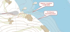
FEMA’s Flood Insurance Rate Maps (FIRMs) or just Flood Maps are provided after a flood risk assessment has been completed or updated for a community. This study is known as a Flood Insurance Study. The FIRM gives you the Base Flood Elevations (BFEs) and insurance risk zones in addition to floodplain boundaries. The FIRM may also show a delineation of the regulatory floodway.
Once the “insurance risk zone” (commonly referred to as the flood zone) is determined, actuarial rates, based on these risk zones, are then applied for newly constructed, substantially approved, and substantially damaged buildings. FEMA uses these rates to determine the insurance rate you will pay for flood insurance
FEMA’s Digital Flood Maps
FEMA discontinued the production and distribution of paper flood maps in 2009 as part of its Digital Vision Initiative. This affected all the Flood Maps, boundary information, and study reports. However, clients can still view the products for free through their website or buy them in digital format.
To view these flood maps online, go to FEMA’s Map Service Center and key in your address (hi-lited area shown here) search for your home. This will prompt you to then select the map that covers your area. The Flood Maps are somewhat cumbersome to use online. It is best to go through the tutorial on the bottom right of the address search page for an easier and more effective use of the GIS map.